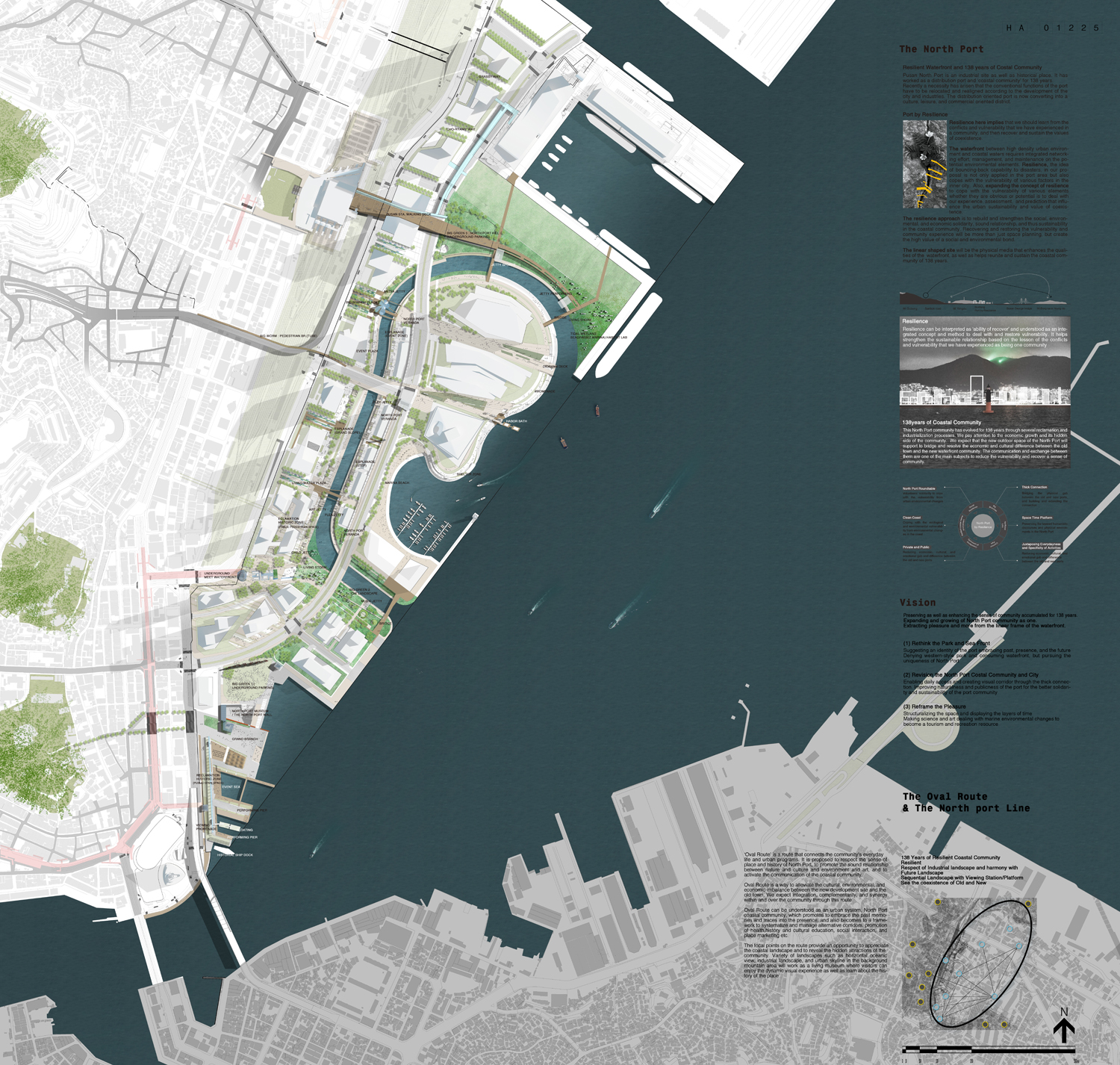
Design by Resilience
PORT by RESILIENCE, International Invited Design Competition for North Port in Busan City, 2014, 2nd Place
북항은 근대기로부터 현재로 이어지는 역동적인 역사현장이자 산업현장이다.
또한 138년을 이어 온 물류항이자 북항을 둘러싼 ‘연안공동체’ 의 생활터전으로서 함께 해왔다.
근래에 이르러 북항의 재래부두 기능을 도시의 성장 및 산업의 변화에 따라 재배치해야 할 필요성이 대두되었고,
물류 중심의 항만 기능이 시민과 문화·여가·상업 중심으로 변화되고 있다.
Pusan North Port is an industrial site as well as historical place. It has worked as a distribution port and ‘coastal community’ for 138 years.
Recently a necessity has arisen that the conventional functions of the port have to be relocated and realigned according to the development of the city and industries.
The distribution oriented port is now converting into a culture, leisure, and commercial oriented district.
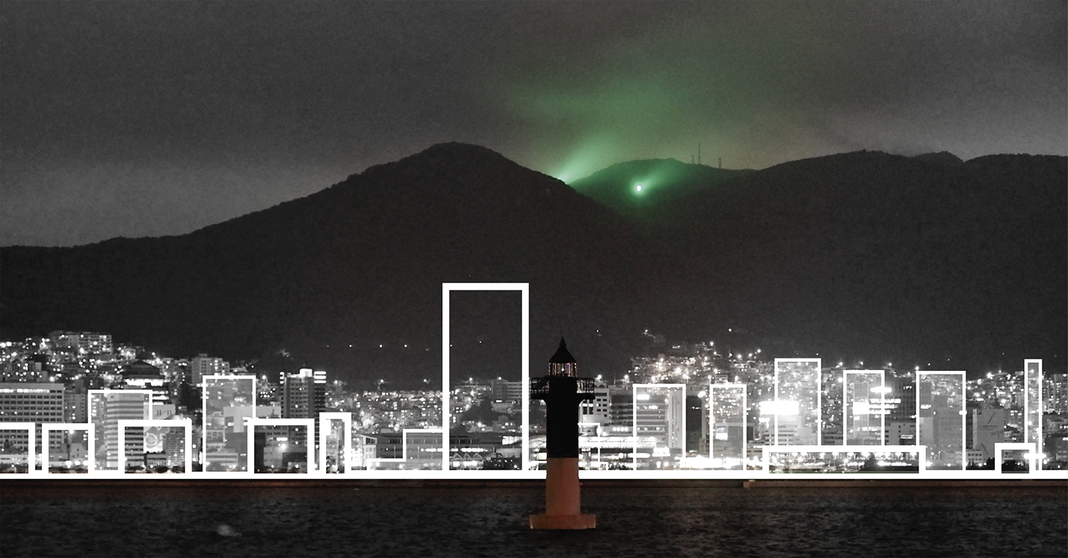
138years of Coastal Community
하나의 연안환경에서 시작되어 138년을 이어 온 북항 공동체는 매축과 근대화의 과정을 거듭하며 성장과 발전을 이루어왔다.
우리는 북항의 경제 발전과 함께 해 온 연안공동체의 성장과 그 이면에 관심을 갖는다. 새로운 북항의 외부공간이 구도심과 새로운 워터프론트 지역의 도시이미지 분리,
발전과 정체에 따른 경제적 차이뿐만 아니라 문화적·정서적 차이를 낮추고 하나의 공동체로서 지속되는데 기여하는 중간자로서 역할하기를 기대한다.
구도심과 새로운 워터프론트 사이의 연결과 교류는 도시 환경의 취약성을 낮추고 연안공동체의 회복을 위한 과제이기도 하다.
This North Port community has evolved for 138 years through several reclamation and industrialization processes. We pay attention to the economic growth and its hidden side of the community.
We expect that the new outdoor space of the North Port will support to bridge and resolve the economic and cultural differences between the old town and the new waterfront community.
The communication and exchange between them are one of the main subjects to reduce the vulnerability and recover a sense of community.
*** Vision
138년 북항 연안공동체 다움을 간직하며 새로워지는 것,
본래 하나였던 북항 연안공동체가 새롭게 확장, 발전하면서 더 큰 활력을 갖는 것,
그 이상의 비전과 즐거움을 워터프론트의 선형적 프레임 속에서 이끌어내는 것.
– Preserving as well as enhancing the sense of community accumulated for 138 years
– Expanding and growing of North Port community as one
– Extracting pleasure and more from the linear frame of the waterfront
(1) Rethink the Park and Sea Front
과거와 현재, 미래가 공존하는 북항 연안공동체의 아이덴티티를 제시한다.
서구적 공원, 소비적 워터프론트를 지양하고 북항 고유의 ‘북항성’을 추구한다.
Suggesting an identity of the port embracing past, presence, and the future
Denying western-style park and consuming waterfront, but pursuing the uniqueness of North Port
(2) Revision the North Port Costal Community and City
두터운 연결을 통해 바다로의 통경과 일상적인 연결이 가능하도록 한다.
새로운 북항의 자연성과 공공성이 구 시내구역과 밀도 높은 교류를 갖도록 하여 북항 연안공동체의 연대와 지속성에 기여하도록 한다.
Enabling daily access and creating visual corridor through the thick connection
Improving naturalness and publicness of the port for the better solidarity and sustainability of the port community
(3) Reframe the Pleasure
축적되어 온 과거와 현재로부터 미래의 공간을 조직화하고 디스플레이한다.
해양과학과 예술의 융합, 전 지구적 해양환경 변화에 대한 대응이 곧 관광, 레크리에이션, 이벤트 경험과 연속되도록 한다.
Structuralizing the space and displaying the layers of time
Making science and art dealing with marine environmental changes to become a tourism and recreation resource
(Re)Framing the Mission
새로운 북항의 공공공간은 워터프론트 내부의 녹지, 여가 장소일 뿐만 아니라 북항 원도심의 앞마당이 되며 육상문화와 해양문화가 만나는 융합공간으로 계획되어야 한다.
이에 더해 구도심이 가진 다양한 컨텍스트와 130여년 동안 누적된 북항의 인문유산을 보존함과 동시에 다양한 방식으로 발전시켜 새로운 북항 워터프론트의 공공공간으로 이어야 한다.
The public space of the new North Port should be not only space for green and leisure, but also the front yard of the old town being united space of land and ocean culture.
Preserving and developing the diverse contexts and cultural heritage of the old town
우리의 계획은 북항이 가진 인문적, 환경적 잠재력을 일깨우면서 연안공동체의 연대를 강화하는 것으로 시작된다. 이를 위해 규정된 공공공간의 토지이용계획을 준수하면서
인접 건축부지의 공공, 준공공 공간 및 구도심 지역과의 연계 가능성을 재구성한다.
Our plan starts with the idea revealing the humanistic and environmental potentials and strengthening the solidarity of the coastal community.
In order for this, complying with the current land use plan, we suggest to reconstitute the connectivity between adjacent public and semipublic spaces and old town area.
계획대상지는 공원으로서의 기능뿐 아니라 본래 하나의 공동체 기반으로 시작되고 발전해왔던 구도심과 북항 워터프론트의 컨텍스트를 연결하는 공간이자 장치가 되어야 한다.
공원을 포함한 선형적 프레임의 외부공간은 자체로서의 완결보다 관계 구축을 이끌어내는 공간적 장치이며 오래된 것과 새로운 것이 만나고 지속력을 공유하는 플랫폼으로서 제시된다.
Resilience – Framework : 견고한 틀의 이야기 Story of Robust Frame
Resilience – Sofrware : 성장하는 북항의 이야기 Story of Growing North Port
The site should be a space as well as device to combine the functions of a park with the waterfront context.
The linear frame of the outdoor space including the park is an open platform where the old and new meet and share the sustaining power together.
경계의 확장 Expanding the Boundary
규정된 토지이용계획을 준수하면서 인접 건축부지의 공공, 준공공 공간 및 구도심 지역과의 공간적, 시설적 연계를 재구성한다.
Complying with the existing land use plan, we propose to reconstitute the connectivity of spaces and facilities between adjacent public and semipublic spaces and old town area.
연결 Connection
철도와 부두로 인해 단절된 배후도심의 일상을 워터프론트로 잇고 해양문화의 특성과 장점을 결합한다.
The waterfront connects the everyday life in the old town with the ocean culture which once disconnected by the railroad and wharf.
점유 / 공유 Private Occupation / Public Ownership
건축, 상업지역이 점유한 경관, 통로를 공공공간과 연계하고 공유되도록 한다. 이를 위한 외부공간과 동선의 연결은 물론 상호 이용가능한 활성화 시설을 계획한다.
Landscape and corridor that are occupied by buildings and commercial facilities will be connected to the public spaces.
The circulation pattern for this is arranged, and facilities are located according to the pattern.
생활권 / 경제 Life Zone / Economy
매축의 역사를 포함한 근대 인문, 산업유산을 통해 구도심과 새로운 워터프론트가 하나의 북항 연안공동체로 결합되도록 한다.
구도심의 육상문화와 북항 워터프론트의 해양문화가 서로의 특성을 보완하고 경제적인 성과를 공유할 수 있도록 연결로와 환경적 장치를 제공한다.
The old town and new waterfront are united as one North Port coastal community through the cultural heritage.
The characteristics of inland culture and oceanic culture actively interact. Connecting paths and environmental devices are provided to promote the interaction and economic vitality.
THE OVAL ROUTE
‘Oval Route’는 연안공동체의 생활루트이자 도시 프로그램 연결루트이다.
북항의 장소성과 역사를 존중하고 자연과 문화, 환경과 예술의 유기적인 관계와 연안공동체의 소통을 이끌어내는 경로로 제시된다.
‘Oval Route’ is a route that connects the community’s everyday life and urban programs. It is proposed to respect the sense of place and history of North Port,
to promote the sound relationship between nature and culture and environment and art, and to activate the communication of the coastal community.
오벌 루트는 대규모 개발지와 구도심과의 문화적, 환경적, 경제적 불균형과 취약성을 극복하기 위한 방법으로 제시된다.
북항을 중심으로 연안공동체와 생활권을 재구성하고 워터프론트의 구역적 경계를 넘어 개별 단위의 연안 구역과 공간들이 제공할 수 없었던
북항 연안을 둘러싼 전체 연안 공동체의 통합과 보완, 상승효과를 기대한다.
Oval Route is a way to alleviate the cultural, environmental, and economic imbalance between the new development site and the old town.
We expect integration, complementarity, and synergy within and over the community through this route.
‘Oval Route’로 이해된 도시시스템 ‘북항 연안공동체/North port Coastal Neighborhood’는 북항 138년의 흔적과 기억을 포괄하는 일과 더불어 과거를 지속시키고
현재와 공존하게 하며 대안적 통로, 건강 증진, 역사문화 인식과 교육, 사회적 교류, 도시마케팅 등을 조직화, 관리하는 고유한 구조로 발전할 수 있다.
Oval Route can be understood as an urban system, North Port coastal community, which promotes to embrace the past memories and traces into the presence,
and also becomes to a framework to systematize and manage alternative corridors, promotion of health, history and cultural education, social interaction, and place marketing etc.
‘Oval Route’를 따라 이어지는 주요 지점들은 북항과 북항 연안생활권의 경관과 숨어있는 공동체의 다양한 장점을 발견하고 드러내는 기회를 제공한다.
경관/프로그램 거점 곳곳에서 바라다 보이는 해양의 수평경관과 활력을 가진 산업경관, 배후 산지의 밀도 높은 도시와 주거경관은 오랜 시간 축적되어 온
박제되지 않고 살아있는 박물관으로서 새로운 북항 워터프론트를 즐기고 특징짓는 프로그램이 된다.
The focal points on the route provide an opportunity to appreciate the coastal landscape and to reveal the hidden attractions of the community.
Variety of landscapes such as horizontal oceanic view, industrial landscape, and urban skyline in the background mountain area will work
as a living museum where visitors can enjoy the dynamic visual experience as well as learn about the history of the place.

Landscape Strategies / Resilient Costal Community
두터운 연결 Widening/Near
– ‘두터운 연결’은 구도심과 새로운 워터프론트의 유기적 소통을 위한 통로이자 워터프론트의 골격이다.
– 철도, 도로 등 교통구조물로 인한 연결의 취약성에 대응하며 통경과 수변으로의 보행연결을 강화한다.
– 계획대상지와 인접한 건축부지의 준공공용지를 결합하여 바다-도시구역-산으로 이어지도록 한다.
Thick Connection
‘Thick connection’ is a corridor for the organic communication between the old town and new waterfront and is the frame of the waterfront.
Visual and pedestrian corridors are to compromise the weak connection due to the infrastructures including railroad and road.
The semipublic spaces around the buildings adjacent to the site are to be combined so that ocean, city, and mountain are connected in a line.
시공간 플랫폼 Condensed Platform: Space-Time
– 매축의 역사를 포함한 근대 인문, 산업유산이 계획 부지 및 북항 구역 전반에서 보존되고 새로워지게 한다.
– ‘북항라인’은 138년 동안 축적된 매축의 기록과 북항의 이야기를 새롭게 하는 방법으로 제시된다.
– 북항라인은 부지 내,외 및 구도심을 포함한 북항 연안생활권 곳곳에서 보존/재생/은유/환유 등의 방법을 통해 디스플레이된다.
Space Time Platform
The old town and new waterfront are united as one North Port coastal community through the cultural heritage.
‘North Port Line’ is proposed to renew the story of the North Port including the reclamation done for 138 years.
‘North Port Line’ is displayed here and there in the port area and the old town in terms of conservation/regeneration/metaphor/metonymy etc.
Resilient Coexistence of Community
-사적영역으로서의 상업공간과 공적영역으로서의 도시기반이 상호협력을 통해 공유가치를 나누도록 한다.
-상호협력적인 환경구축을 위해 공유장치들을 제안함으로써, 지속적이며 경제적인 성과를 나누도록 한다.
-건물구역의 준공공 영역과 공공구역의 통합적 계획으로 시민과 방문자에게 문화기능과 편의를 제공한다.
The commercial area as private sector and urban infrastructures as public sector share the benefits by mutual cooperation.
By proposing several sharing devices for the mutual cooperation, sustaining economic benefits are properly distributed.
Integrative plan for semipublic and public space around the building area provides cultural functions and convenience to the public.
North port by Resilience
-계획부지는 그 자체로서의 완결성을 가지기 보다 소프트웨어/하드웨어적인 관계 구축을 이끌어 내는 공간적 장치가 되도록 한다.
-부산의 자생적 시민활동인 라운드 테이블과 지역주민, 지역문화단체 등의 적극적인 활동을 이끌어내는 환경적 장치들과 프로그램을 제공한다.
-정체수역의 청정성을 유지하기 위한 노력과 함께 전지구적인 해양환경 변화를 기록하고 체험하는 프로그램, 해양안전/탄성력/복원력을 가지는 연안 경계를 제시한다.
The site is to be an open spatial device that promotes sound relationship by means of both software and hardware.
Environmental devices and programs are provided for the Roundtable, voluntary civic participation of Pusan citizens, neighbors, and local cultural groups.
Coastal area alerting plan is provided to maintain the cleanness of standing water area, an experience program on the changes of the global oceanic environments, and ocean safety/ resilience/ restoration etc.
Big branches
-유기적 소통을 위한 통로이자 골격
-건축부지와 공공용지와의 장래 결합을 고려
-보행과 녹지축을 확장하고 두텁게 연결
-다양한 공원활동의 바탕을 제공
Corridor and frame for organic communication
Considering potential connectivity to the building area and public spaces
Expanding and thickening the pedestrian and green axes
Providing the ground for various park activities
The North port Line
-138년의 매축의 역사와 이야기를 특성화
-구도심과 건축지역을 포함한 부지 전체에서 디스플레이
-북항 워터프론트 시설 디자인과 병행
– 보존, 복원, 변경, 재생, 은유, 환유
Characterizing the history and stories of the 138 year old reclamation
Displaying the story all over the site
Associating with the facility design in the waterfront
Conservation, restoration, change, regeneration, metaphor, and metonymy
Common Park
-생활, 문화공원으로서의 워터프론트
-북항 연안생활권 주민 모두에게 제공되는 공원시설과 프로그램
-고밀도의 북항 연안생활권에 대규모의 열린 녹지와 수변 산책길 제공
Waterfront as living and cultural park
Providing park facilities and programs to all the coastal community members
Large open space and waterfront promenade in the dense urban area
Resilient Coexistence of Community
-사적영역 으로서의 상업공간과 공공공간의 결합
-경관, 공간자원의 공유를 위한 장치제안
-구도심과의 경제적 성과를 나누는 상호협력적 환경장치로 제시
Combining commercial area as private space with public space
Proposing devices to share landscape and spatial resources
Environmental device to share the economic benefits with the old town
Resilient Coastal Marine Environment
-정체수역(경관수로)의 청정성 유지
-연안환경에 대한 안전과 구호에 대한 협력체계 구축
-탄력과 복원력을 가지는 연안경계
-전지구적인 해양환경 변화에 대한 기록
Keeping the standing water area clean
Building a cooperative system for security and safety of the coastal environment
Monitoring and recording the changes of the global oceanic environment
Social Resilience
-북항 연안 공동체를 재활성화
-사회적, 환경적, 경제적 결속력과 지속성, 안전한 관계를 재구축
-시설, 프로그램적 협력과 보완을 통한 가치를 공유
-경제적인 연대와 공존
Revitalizing the coastal community in North Port
Restructuring social, environmental, economic solidarity and sustainable and safe relationship
Sharing the benefits through cooperation by means of operating facilities and programs
Economic solidarity and coexistence
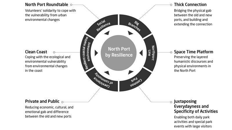
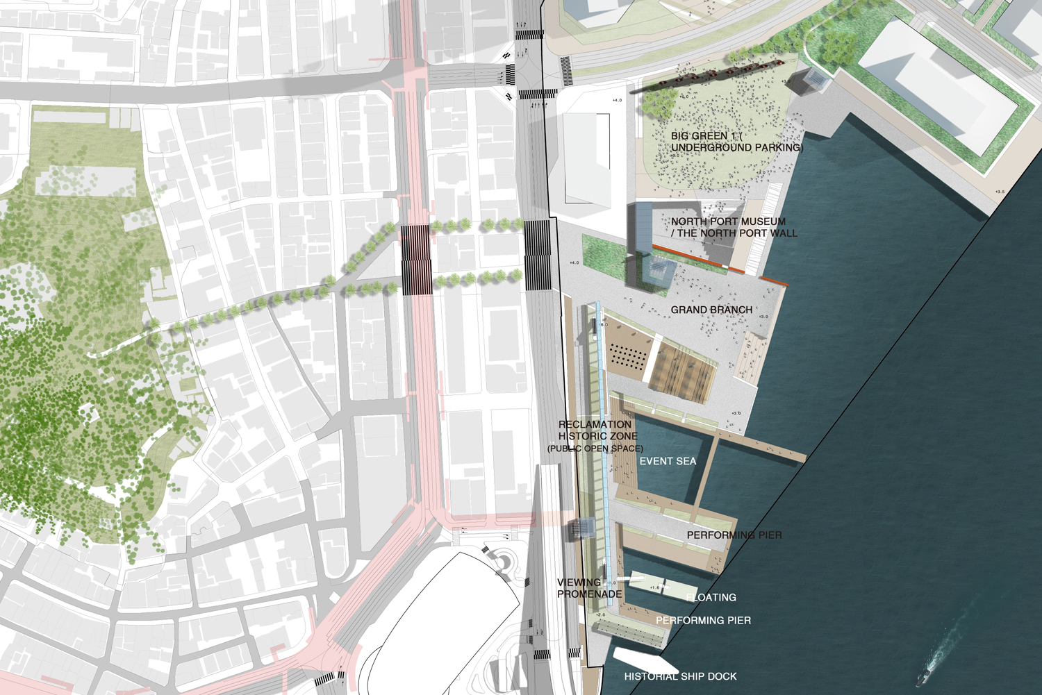
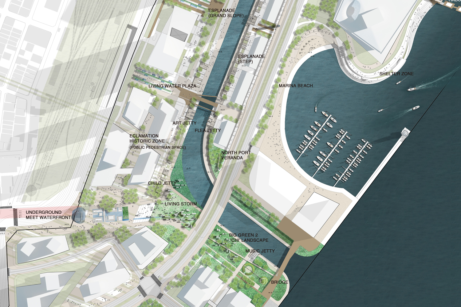
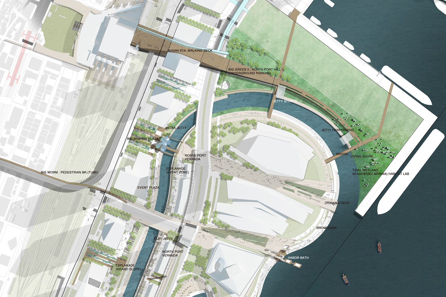
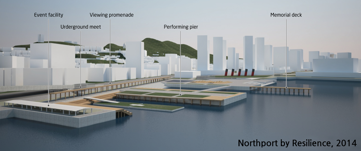
Big branches
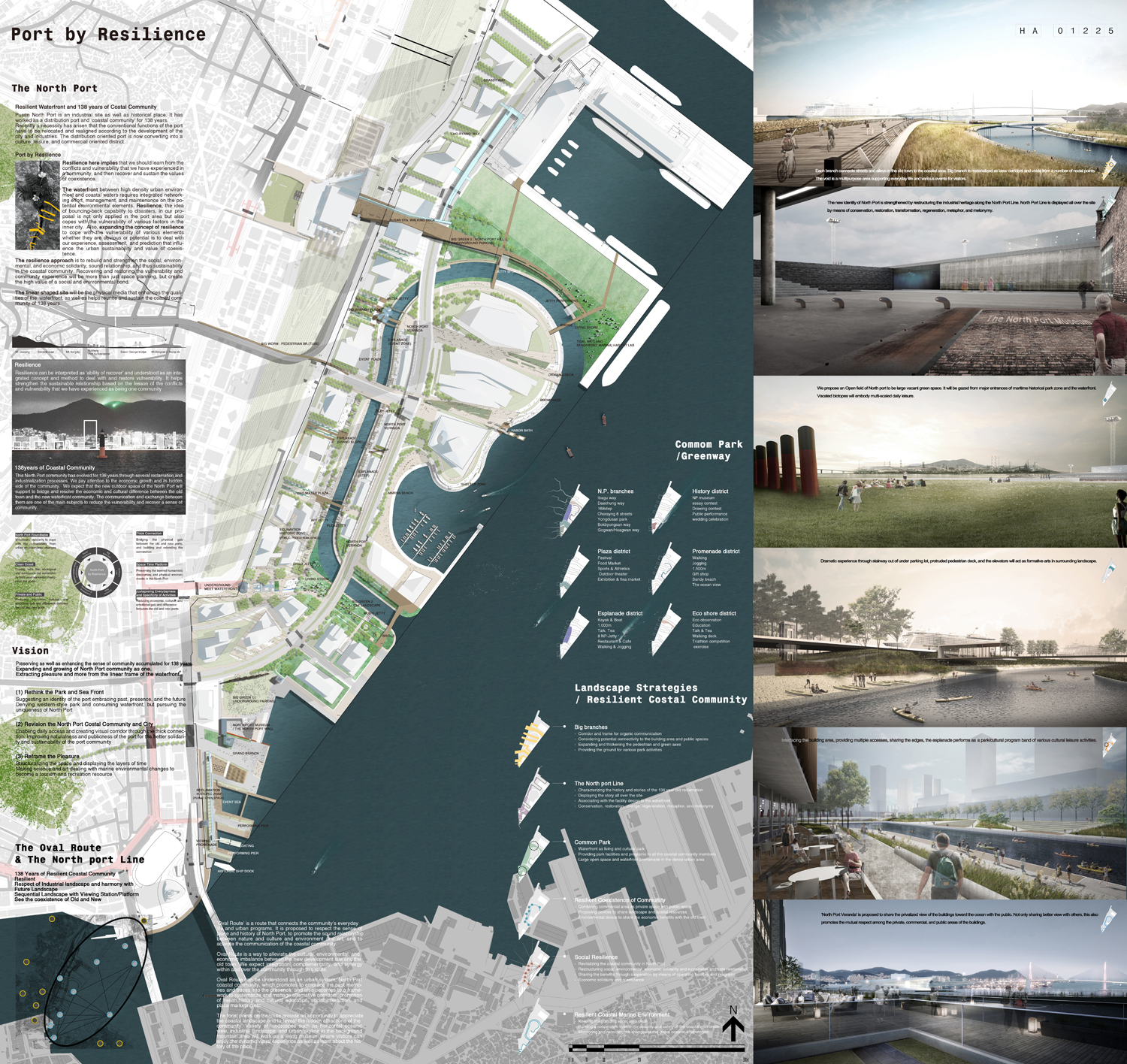
빅브랜치는 유기적 소통을 위한 통로로서 두터운 연결과 워터프론트의 골격을 제공하며 철길, 도로구조물 등의 교통인프라로 인한 보행과 소통의 취약성을 극복하고, 배후 도심의 생활영역과 워터프론트를 잇는다.
빅브랜치는 워터프론트 내 계획대상지와 계획 제안지역, 선형의 녹지와 인접한 건축부지의 공공용지를 포괄하여 두터운 연결을 확보하고 지하철, 버스, 기차 등의 대중교통을 통해 외부구역과 연결된다.
각각의 브랜치는 구도심의 여러 블록에서 이어지는 가로와 골목길을 해변으로 이어주며 구역 전체의 흐름과 연결을 강화한다. 빅브랜치는 구도심과의 여러 연결지점으로부터 해변까지의 통경과 비워진 공간으로 구체화된다. 비워진 공간은 다양한 일상의 활동 및 방문자를 위한 이벤트 공간을 제공하는 등의 여러 목적으로 사용할 수 있다.
Big branch is a corridor for the organic communication between the old town and new waterfront, and the frame of the waterfront.
It embraces the site, proposed area, linear green space, and adjacent buildings’ public space, and is widely connected to public transit such as subway, bus, and train.
Each branch connects streets and alleys in the old town to the coastal area. Big branch is materialized as view corridors and voids from a number of nodal points. The void is a multipurpose area supporting everyday life and various events for visitors.

The North port Line-1
130여년의 시간동안 반복되어 온 매축의 역사는 곧 이곳 북항 구역의 성장이야기이며 물과, 땅, 사람들의 여러 이야기를 담고 있다.
매축의 역사는 현재 북항의 곳곳에서 발견할 수 있으며 배후의 구도심에서는 대부분 지층 하부에 묻히거나 잠재되어 존재한다.
기능적 확장을 통한 매축의 역사는 북항 워터프론트 부지 내외를 아우르는 ‘ 북항라인’으로 재구성되며 북항성(性)을 위한 미학적 외부공간의 틀이 된다.
북항라인과 함께 부지 곳곳에서 드러나는 산업유산들은 활력과 기억의 장소이자 장치로서 재구성되어 과거와 현재, 미래가 공존하는 새로운 북항의 아이덴티티를 형성한다.
북항 라인은 건축지역을 포함한 부지전체에서 보존, 복원, 변경, 재생, 은유, 환유되어 디스플레이되고 작동하게 된다.
The history of reclamation is the story of how the North Port has evolved over 130 years. It can be found here and there in North Port and potentially exists in the old town whether buried or exposed.
The history of North Port is rearranged on the North Port Line which runs in and out of the site, and works as an aesthetical framework emphasizing the sense of place.
The new identity of North Port is strengthened by restructuring the industrial heritage along the North Port Line.
North Port Line is displayed all over the site by means of conservation, restoration, transformation, regeneration, metaphor, and metonymy.
The North port Line-2
오랜시간 동안 매축된 다양한 층위의 역사는 북항의 이야기와 정체성을 담고 있다. 시대별 매축기에 따라 연결되는 크고 작은 다양한 사건, 기념, 인물들은 새로운 워터프론트에 재구성되는 북항 라인과 함께 부지 전반에 풍부한 이야기를 제공한다.
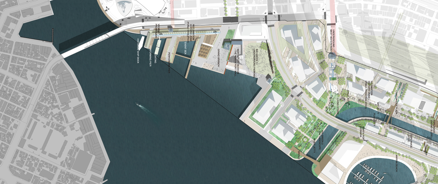
역사문화지구에 포함된 연안여객부두의 안벽은 부지전체의 새로운 계획고인 +4.0m 보다 낮은 +1.8m에 존재하며 누적된 시간과 공간적 층위를 보여줄 수 있는 근대유물로서 보존되고 디스플레이 된다.
보존되는 안벽은 지하주차장에서 지상의 워터프론트로 이어지는 경로에 설치되며 선큰공간을 활용한 극적인 북항 역사박물관으로 통합 조성된다. 안벽은 유리벽을 통해 관찰할 수 있는 해수면의 변화와 낡은 콘크리트 포장재료, 코르텐 스틸 조형 포장요소와 함께 북항의 메모리얼 전시벽으로 특화된다. 시기별로 분류되는 매축라인은 부지 내 외부에서 포장구간, 시설물, 녹지경계, 조명, 정원, 조형적 공간처리 등의 다양한 방법을 통해 연속적으로 이어지며 북항 전반에 계획된다.
The history of reclamation represents the story and identity of the port. Each time when reclaiming work was implemented contains each event, memory, and characters, which provide abundant stories about the site. The level of the piers of the Yeonan ferry terminal is +1.8m which is lower than the newly planned level, +4.0m. They are preserved and managed to display the layers of time and space.
The preserved piers are placed on the path that connects the underground parking lot to the waterfront. The sunken space is utilized as a historical museum of North Port. The piers are specialized as a memorial wall that includes observing spots for sea level changes through a glass wall and worn-out concrete and sculpted corten-steel pavement. The reclamation line can be categorized by time, and displays all over the site by means of pavement, facilities, green boundary, lighting, garden, and form-modification on space.

Common Park /Greenway 보편적 공원/그린웨이
보편적 공원/그린웨이는 공원에서의 여가활동과 지역주민들의 일상적 생활을 위한 것이다.
보편적 공원과 그린웨이는 에스플라나드의 수변공원 구역과 세 곳으로 최대화 된 두터운 물과 뭍, 생명의 교류지와 함께 자연성을 높인 Big Green 해양산책길을 중심으로 계획된다.
구시가지로부터 바다로 향하는 남북방향의 연결뿐 아니라 워터프론트를 따라 이어지는 동서방향의 연결을 통해 부지전체에 계획된다.
보행 및 자전거 동선을 체계화하여 연결을 편리하게 하며 종합적인 도시공원의 기능을 담아 건물구역과 오픈스페이스의 소통이 원활하게 이루어지도록 한다.
그린웨이는 대상지 배후 구도심과 산복도로의 다양한 문화를 체험할 수 있는 구도심 북항라인 길로 연속되어 도심활성화 에 기여한다.
Common park and greenway work for leisure activities and daily life for neighborhood, and include esplanade, waterfront park, three water and land, and Big Green of coastal promenade.
They are placed all over the site connecting south and north as well as east and west.
Pedestrian and bicycle network is suggested to connect the building area and open space, performing urban park functions.
Continuing to the North Port Line, greenway helps vitalize the old town providing various cultural experiences.

Resilient Coexistence of Community-1 : North port Esplanade & NP-Berth
에스플라나드(경관수로)는 양안으로 건축지역과 맞닿아서 다발적인 접근과 경계를 공유하며 문화 및 여가활동을 담는 공원/문화 프로그램 밴드의 기능을 갖는다.
에스플라나드는 수로를 따라 이어지는 ‘길의 장소’를 형성한다. 길게 이어지는 경로를 따라 활발한 공공예술의 참여를 기대하며 문화, 예술을 에스플라나드의 주요개념으로 설정하여 경관가치를 향상시키고 북항 워터프론트의 주요 구역이 되게 한다.
친수/경관수로로서의 에스플라나드를 위해 안전성을 확보한 레벨을 기준으로 물과의 접촉면을 늘리고 친수활동을 가능하게 한다.
에스플라나드의 각 공간과 장치들은 건축물의 사적, 상업적 공간과 공유된다. 공간과 장치의 공유, 상호 협력을 통해 구역 전체의 활성화와 경제적인 성과를 나눈다. 에스플라나드의 각 port에 구축된 ‘NP-Berth’는 수변환경을 통합적으로 이어주는 공간적 장치로서 자생적인 사회적 탄력성을 이끌어내는 매개가 된다.
Interfacing the building area, providing multiple accesses, sharing the edges, the esplanade performs as a park/cultural program band of various cultural leisure activities.
It creates a place of paths along the waterway. The main concept of the esplanade is culture and ar, and we expect dynamic people’s participation on public art.
Securing the level of water for safety, we propose to increase the water-interfacing area of the esplanade for more lively water-related activities.
Each space and device in the esplanade is shared with buildings’ private and commercial area, which is expected to promote the vitality and economic benefits of the community. ‘NP-Berth’ in each portis a spatial device that syntagmatically connects the waterfront environment. It performs as a media that encourage voluntary social resilience.

Resilient Coexistence of Community-2 : North port Veranda
‘노스포트 베란다’는 건축물에 의해 사유화된 바다로의 파노라마 조망과 연결을 공공과 나누는 방법으로 제시되었다. 이를 통해 건축물의 사적, 상업적 영역과 공공영역이 상호의 가치를 존중하고 조망과 경관을 보다 폭넓게 공유할 수 있다.
노스포트 베란다는 공중 프롬나드/옥외실 구조의 환경적 장치로 제시된다. ‘North port Veranda’는 휴먼스케일의 에스플라나드와 도시경관 스케일의 워터프론트를 입체적으로 연결하며 광대한 북항 앞바다의 도시경관을 조망하며 걷는 즐거움을 제공한다. 북항베란다는 에스플라나드로 향한 건물의 기능을 워터프론트로 확장하여 건축물의 이용성과 가치를 증대시키며 보행 레벨에서 그늘을 제공하는 회랑으로서도 제공된다.
‘North Port Veranda’ is proposed to share the privatized view of the buildings toward the ocean with the public. Not only sharing better view with others, this also promotes the mutual respect among the private, commercial, and public areas of the buildings.
North Port Veranda is a device consisting of promenade and outdoor room. It connects the esplanade of human scale with the waterfront of urban scale in three dimensions. It increases the functionality and values of the buildings and also forming a gallery providing shade to people at pedestrian level.

Resilient Costal Marine Environment
연안지역의 레질리언스는 재해로 인한 충격을 최소화하고 복구능력을 극대화 할 수 있는 기반을 제시하여 탄력적인 안전성을 구축하는 것이다. 이에 더해 재해로부터의 보호와 안전, 연안에서의 안전과 구호활동에 대응한다.
레질리언스 연안은 바다와 맞닿는 워터프론트의 해양경계와 경관수로의 두가지 연안을 구분하여 계획된다.
해양경계에서는 태풍 해일, 월파, 강한 바람 등에 대응하는 환경적 장치와 연안경계를 구축한다.
연안 경계는 북항이 경험한 자연재해의 규모와 영향뿐 아니라 전지구적인 해양환경의 변화에 대한 지식과 시설적 경험을 제공하며 장기적이고 교육적인 목적의 연안경계로 특성화되어 디스플레이된다.
경관수로에서는 에스플라나드의 친수경계 및 육상공간과 관계를 맺도록 구성된 해수 수로의 청정환경 유지에 주목한다. 경관수로는 정체된 해수 수로로서 녹색공간과 물길 등을 조성하고 보호함으로서 예측가능한 환경적 문제와 스트레스에 대해 적응력 향상과 해법을 제시한다.
Planning resilience in the coastal area is to minimize the impacts from any disasters and to maximize the recovering capability. Also, it deals with safety and relief activities as well as security from disasters.
It is planned for two divided areas: the coastal boundary of the waterfront and scenic waterways.
The costal boundary includes defensive devices against storm, tsunami, wave overtopping, and strong wind, and coastal monitoring system.
The coastal monitoring system provides knowledge and educational opportunities about historical experiences of North Port as well as changes of the global oceanic environment.
Maintaining clean environment is important in the scenic waterway. It is a water feature of standing sea water. We propose to create and protect green space and waterways, and to provide resolution on the anticipated environmental issues.
Anticipate_ : 재해 영향의 예측 및 평가, 위험으로 인한 피해를 감소시키기 위한 장기적인 활동
경관적 가치, 생태적 가치는 물론이고 기후변화에 따른 환경변화의 적응 능력, 방재능력을 유지한다. 외부충격에도 원래 상태를 유지하거나 스스로 복원하여 자기조직화(self-organization) 하고 적응력(adaptation)을 지속적으로 높이는 연안해양환경의 레질리언스를 강화시킨다.
Long-term activities to reduce the risk from disasters by anticipation and assessment
We should maintain not only the values of landscape and ecosystem, but also the capability of adaptation and prevention against disasters.
We should strengthen the resilience that sustains the original condition or self-restores from outside impact.

Social Resilience
138 Years of North port Costal Community
138년 동안 함께 해 온 북항 연안공동체가 새롭게 확장, 발전하면서 더 큰 하나로서 상호 활력을 갖도록 돕는다. 북항 연안공동체의 사회적, 환경적, 경제적 결속력과 지속성, 안전한 관계를 재구축하는 목표를 두고 사회적 레질리언스를 강화한다.
현재 부산 및 북항 지역에는 도시의 성장과 균형을 위한 다양한 시민활동이 활발하게 운영되고 있다. 북항의 외부공간은 공원의 기능을 넘어 라운드 테이블 방식의 수평적 협의체, 참여적 기부활동, 자발적인 문화, 예술, 환경활동 등이 더욱 활발하게 연계될 수 있도록 매개적인 틀을 제공한다.
이를 통해 한정된 대상지를 넘어 새로운 북항 워터프론트의 가치를 보다 향상시킬 수 있다.
We proposed that North Port coastal community should develop and grow further as a bigger one. Also, the resilience should be strengthened for rebuilding the social, environmental, and economic solidarity, sustainability, and sound relationship.
Currently, there are diverse citizen activities for balanced urban growth in Pusan and North Port area. The outdoor space of North Port provides an intermediary framework for horizontal consultative groups, participatory donations, voluntary cultural activities on art and environment over just regular functions of urban parks.
Therefore, our proposal supports to enhance the values of the waterfront of North Port over the site boundary.


